These products are used for reading aerial photograph and map study. These products are manufactured using latest technology machinery and skillful group of employees to ensure superior quality and long lasting performance. These products are known for their compact size and dimensional accuracy.
Description
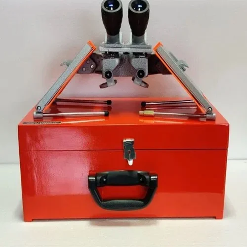
The Mirror Stereoscope With Binocular is an essential learning instrument used in geography, surveying, and remote sensing education. It allows students to view paired aerial photographs in three dimensions, which helps them understand terrain features, elevation differences, and landform structures. As a result, learners develop strong spatial interpretation skills through direct visual observation.
Educational institutions across India commonly use stereoscopes in map study and photogrammetry practicals. Similarly, universities and training centers in countries such as the United States, the United Kingdom, and Australia rely on mirror stereoscopes to teach aerial photograph interpretation in a classroom environment.
Mirror Stereoscope With Binocular for Aerial Photograph Reading
The Mirror Stereoscope With Binocular enables clear three-dimensional viewing of aerial photographs. Instructors use it to explain how overlapping images create depth perception. Therefore, students can easily identify contours, drainage patterns, vegetation, and built-up areas during practical sessions.
Because the binocular viewing system offers comfortable eye positioning, learners can study photographs for longer durations without strain. Moreover, the mirror arrangement increases viewing distance, which improves clarity and image interpretation accuracy.
Mirror Stereoscope With Binocular for Map Study Education
The Mirror Stereoscope With Binocular plays a key role in teaching map reading and terrain analysis. Teachers often use it to demonstrate slope identification, relative height estimation, and landform classification. Furthermore, it helps students connect topographic maps with real-world aerial imagery.
Training programs in countries such as Canada and Germany frequently introduce stereoscopic viewing to explain remote sensing fundamentals. Consequently, students gain early exposure to techniques used in professional geographic analysis while remaining within an academic framework.
Compact Design and Dimensional Accuracy
The stereoscope features a compact and precisely manufactured structure, which ensures consistent optical alignment. As a result, students receive reliable depth perception during demonstrations. Additionally, the durable construction supports repeated use in educational laboratories.
Education and Demonstration Use Only
This mirror stereoscope is intended strictly for education, training, and demonstration purposes. It is not designed for industrial photogrammetry, commercial surveying, or professional mapping operations. Instead, it supports safe learning, conceptual clarity, and academic skill development.
Applications
- Aerial photograph interpretation
- Geography and remote sensing practicals
- Map reading and terrain analysis learning
- Teaching photogrammetry basics
- Surveying and earth science education
other educational working models and laboratory kits to enhance hands-on learning in engineering and technical laboratories. In addition, institutions may also explore complementary learning solutions such as Jaadui Pitara educational learning kits to support interactive and concept-based education.
See also different:

Aluminum Leveling Staff
Prismatic Compass With Stand
Survey Measuring Chain
Brass Brunton Compass