The term “plaque models” typically refers to two different concepts depending on the field: atherosclerotic plaque models used in biomechanics and medicine, and geomorphological models (which may include relief models or terrain plates) used in geography education and research.
Description
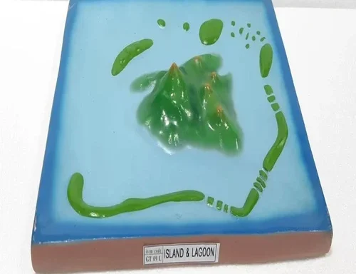
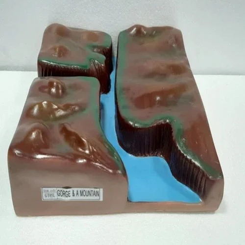
Plaque Models Geomorphology are educational teaching aids designed to visually represent Earth’s surface features and landform processes. These models present terrain, relief, and geomorphological structures on flat or slightly raised plaques, making complex physical geography concepts easier to understand. As a result, students can clearly observe how natural forces shape landscapes over time.
Schools, colleges, and geography departments across India commonly use geomorphology plaque models for classroom instruction. In addition, educational institutions and training centers in countries such as the United Kingdom, South Africa, and Kenya rely on these models to support hands-on learning in physical geography.
Plaque Models Geomorphology for Landform Understanding
Plaque Models Geomorphology help explain the formation and classification of landforms such as mountains, plateaus, plains, valleys, river systems, deltas, coastal features, and deserts. Teachers use these models to demonstrate elevation differences, slope variation, and surface patterns. Therefore, learners gain a clear spatial understanding that textbooks alone cannot provide.
Because the plaque format presents features in a fixed, stable layout, students can easily identify and compare geomorphological structures. Moreover, labelled elements support independent learning and revision.
Plaque Models Geomorphology for Earth Surface Processes
Plaque Models Geomorphology also illustrate dynamic processes such as erosion, weathering, deposition, volcanism, and river action. Educators use them to show how water, wind, ice, and tectonic forces modify Earth’s surface. Consequently, students understand the relationship between processes and resulting landforms.
In higher classes, these models support explanations of drainage patterns, watershed development, and landscape evolution. As a result, learners build strong conceptual links between theory and observable geography.
Durable Construction and Classroom-Friendly Design
The models are typically made from durable materials with textured surfaces to represent relief clearly. Additionally, the flat plaque format allows easy wall mounting or table-top display. This design supports repeated classroom use without damage and ensures long-term educational value.
Suitable for Teaching and Academic Demonstration
These geomorphology plaque models are suitable for school classrooms, geography laboratories, colleges, teacher training institutes, and science exhibitions. They align well with curriculum requirements for physical geography and earth science.
Applications
- Teaching geomorphology and physical geography
- Understanding landforms and terrain features
- Demonstrating erosion and deposition processes
- Geography classroom demonstrations
- Academic reference and exam preparation
For institutions and laboratories planning to expand their scientific infrastructure, a wide range of biology laboratory instruments and teaching aids is available at
https://www.aseducationalkits.com/products-category/biology-lab-equipments/
In addition, educators and procurement teams can explore a broader selection of educational science items and classroom resources at
https://www.labscientificequipments.com/product-category/educational-items/